|
Transalp 2013. From Geneva to Como - best one yet
As some may know, I had a bit of an accident a few weeks ago that's taking a bit of getting sorted, to re-adjust to life as it's not going to be the same again. One thing it's made me do is write up last years trip and get it on the Web so that hopefully others might enjoy it or use the material to do a better trip themselves. Here goes, make a cup of tea and get a comfy chair before you start!
Trip write-up. Transalp 2013. From Geneva to Como.
The intention of this write-up is to be such that others can follow the route, can improve on the route. That’s why it includes a lot of place names etc. It is also hoped that it will encourage other UK riders to take to the mountains and do their own traverses of mountainous areas over multiple days and self supported. We took 35 sheets of maps, A3 of the 1:25k map, reduced to 1:30k with the planned route marked on it. It is in PDF format. Also available is the GPX trace of the route we actually rode. A spreadsheet of the planned route showing leg by leg each one being about 2 or 3km and a kit list that we use as a general list year on year.
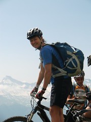
This years trip was to be a West to East traverse of much of Switzerland. Much of it in part’s I’ve never biked across before (as none of the rest of our group had either) and on trails that we were to find information on was sparse. We spend a huge amount of time before the trip, researching the route, looking at it on maps, on GoogleEarth and generally searching round (mainly the Web) for any information or photos at all about the track we might be taking. This time the group was very different to previous years. Gone was the 2 or three max in the group, this one was 7. Yes SEVEN! That made me very uncomfortable and worried about the time it would take us faffing. Most were new to Transalping and so unknown to the pressure that comes with being self reliant for many days. Three of them were girls which again was a new thing. As it turned out, it could not have been better. The group was brilliant. Not a cross word, not a single grump and so thoroughly enjoyable being together every minute of every day. The girls were so embarrassingly strong!
The group then; me – knowing the mountains from caving and paragliding and probably better at planning and map reading than racing! Pete – IT boffin, just as good as anyone in the mountains and very fit – again a paraglider pilot, climber and general outdoor man. Gary – another IT man, strong ex-racer making the three of us that ‘normally’ makeup the Transalp group. Richard – always juggling racing and hard riding with running an executive empire. Phil (Philippa) my ex-trailquest and Polaris partner. A vet up in Cumbria and lives for the outdoors. Ruth a GP in the lakes. A friend of Phils and new to the rest of us but turned out to be the demon-downhiller putting us all to shame and lastly Lucy, another GP in the Lakes. Makes her money as doctor to expeditions and events and proved to be a real hard cyclist.
Day 1
Was our transit day. 6 July 2013. Flying out from Manchester and London to Geneva. It seemed every cyclist in the world was there as many people were flying out to do the Etape du Tour. All the team GB people were there to fly out to a round of the Worlds. A number of offroaders were going out o the usual Les Gets/Morzine/Les Arcs etc and then us in our ready-to ride gear and bikes in boxes to abandon. We saw a few guys who we knew (including Stu from Dales MTB Centre) and unbeknown to me Laura Trott and Beck James snapped my picture in the airport and put it on Laura’s Twitter page. Fame at last! (or was it because we looked so strange in full cycling gear clip-clopping around in cleated shoes)
At Geneva we’d planned to cheat the first 40k which was on road from the airport and climbing 650m.

We’d arranged a bus mainly in case the weather was poor, our flights were late and to make sure we hit the first night in time. As it turned out, the weather was good and we landed on time but we still hit the first night just as daylight was going. Another 2 hours spinning out of Geneva would, it turned out, have spoiled it. From leaving the bus in the hamlet of Bogeve we were going over meadows and 
woodland that looked to be hardly used. It was all around 1200m so was quite lush and wooded and route finding was difficult. We ended up taking a track that was not the one we’d planned but that was a great steep old track, mainly in a gully, rough and slippery and full of leaves. That dropped us to the road and some more good track to the bed for the night. We’d booked the first night too at a gite (we’d seen on the Web) in advance. It turned out to be a gem. A large house with husband and wife, a kid of about 8 and grandma. No English spoken (which was how we would want it) and they fed us to death with meat fondue and so much drink. Hopefully this hospitably would be a sign of things to come.
Day 2
This was our first full day in the saddle. Or so it wasn’t to be! Up through woodland to col des Betets and Haute-Pointes. All good track but sometimes too steep to ride and sometimes wet as we were in the cloud although never raining.

When the clouds parted near the summit we were faced with a huge falaise (French cliff) of about 200m high which was a stunning sight.


A short road then double track over the col de la Bolire and down to the road col de l’Encrenaz at the edge of the Les Gets resort area. We took lunch there and laughed with a group of three UK roadies from East Anglia who had flown out for a long weekend, first time from the UK, hired bikes and were stunned by the hills of the Alps. Well they would wouldn’t they! After chips at the col café, we set off down towards Les Gets on the narrow forest track. After a couple of Km, we came across a woman in distress who told us her small (11 year old?) girl had fallen off her bike over the edge and down the steep slope. Her dad had tried to find a way down but was struggling. When we looked we saw a gully, cliff and gully and she had clearly had a very, very long fall. Dr Lucy and I biked on for 500m to find a place to climb down which even that took us 20mins to get down. It seemed an age. I had renewed my mountain first aid only 2 weeks before and between us we had more dressings and drugs that a small cottage hospital. The little girl had fallen about 80-100m vertically and her helmet was wrecked. When we got there we found Alice clearly in shock, with a few fractures and her dad, Ross by her side but not making much sense. It turned out Ross lived near us in the Lakes and was very happy that we had turned up. We diagnosed and treated her and made the scene as safe as we could then made ready to guide in the winchman. Our guys left on top were able to call in the helicopter with GPS co-ordinates and less than an hour later Alice was being winched up and off to Annecy Hospital. I think the winchman and winch-doctor too were happy to see things were well sorted and we had English-speaking doctor on the scene as immediately they landed we were able to get a unit of fluid into her and pain relief.


We climbed back up to the track (a mean feat in itself!).
When we re-grouped, we realised we had missed any chance of getting to Switzerland that night but if we really, really raced might make the Chavannes lift out of Les Gets so be able to spend an hour along the tops dropping into Morzine for the night. We rode so fast into Les Gets and crossed the town to the lift. We were after the closing time (by 15 minutes) but the guys there let us on, we thanked them so much and they even waved us on without paying. Our good deed had payed us back although they never knew that. On the tops, we had the whole resort to ourselves, we enjoyed the evening sun as we rode across to Le Plenay and whooped all the way down the downhill course into Morzine town.

When we got there the Office du Tourisme pointed us to a bikers hotel, ran by an irish guy which turned out to be great. As we walked into the bar there Andy Murry on the big screen took championship point and the place erupted. We met with guys we’d last seen in the airport and swapped tales. To cap the evening off, Ross called to say Alice was being treated well at Annecy, he had just got there and she was going to be OK. We’d had a great day.
Day 3
We woke up to a clear blue sky. We were the first to breakfast and made a good start to be the first at the lift. The hotel was good but the seasoned Transalpers amongst us had promised the rest tales of sleeping in mountain huts, roughing it at altitude.

The disappointment had been tempered by a hearty breakfast! Today’s task was scooting across the Morzine/Avoriaz/Chatel resort area and across the huge Rhone valley to get into the Swiss Alps proper. I had emailed some of the established MTB companies in the resort to try and get a good XC route across their area but failed to get any useful information. It turned out our route (we had made up from the 1:25k maps) was brilliant anyway! The final lift had got us to Super-Chatel then we took small footpaths from 2000m right down to a rough road at 1100m before the valley bottom at 400m.

Fantastic riding. Many of the fences have curious swiss grids across to allow for bikes or walkers but keep the cattle in. Then span across the valley, doffing our hats to the UCI headquarters at Aigle and lunch there of bread and cheese outside a Co-op. We knew we were at a very low altitude and sure enough the only way was up! We needed to get to Leysin (1300m) to get the last lift up. As we’d noticed an hour before cu-nim clouds were building but we were still super-hot and basked in sunshine.

On the long slog up the road to Corbeyrier (900m) we started to witness the impending storm and by the time we were on the singletrack in the woods, the heavy rain started. Phil had bust her spring in the rear mech and as we got into Leysin, the town was awash with rain, we’d missed the lift and just managed to get to a bike hire shop to get a spring. The guy in the bike shop was adamant that the mech could not be repaired but at the risk of loosing time, we bought a new mech and took the spring out of it and butchered it.

We fixed the bike and found a bed. This time in an Ibis hotel. Nothing could be further from roughing it at altitude. I was starting to feel a fraud. That tempered slightly as we ate pizza in a nearby bar. We looked like a fashion disaster but we did have white linen bedding! We were at 145Km. It rained hard and long into the night but we had our stuff drying on the radiators. We knew it was an alpine storm and should bode well for the next day.
Day 4

Today I am determined to end up at a high mountain hut! We make the most of the hotel breakfast buffet and nick huge amounts of food to make sandwiches – partly to save money but also to limit any stopping we need to do. We make the first lift that takes up to 2050m and a clear blue but freezing morning. Within 20 minutes we are at the hut we should have made. It looks fabulous. An old woman there tells us the path to take but in true UK style we don’t understand enough of it and baz off down the wrong track. We quickly find what she was telling us about, a climb down a rock gully with fixed chains, probably 50m and not really meant for bikes!

It feels now like we’re having a real adventure. A few Km of riding across meadows, in fantastic full flower and then racing along a track.

All is flowing well til I hit a grid on a bend that the rider in front has muddied. The bike slips from beneath me and I fall chest first onto a low fence post. I am in agony.

This pain goes on for the whole trip and months after as it turns out I have fractured ribs. Bummer! Luckily I am fully tooled up with Tramadol in my kit, plus Dr Lucy brought some and along with other drugs it’s bearable! Taking a 3x dose every night makes me sleep and keeping off them in the day allows me to ride. We make it on tracks up to Leyxay at 1650m then find a superb wooded and meadow trail taking us right down to La Lecharette at 1350m. Road to L’Etivaz 1100m and there we eat our ‘stolen’ lunch. Ruth gets ice creams from a bar and with that we’re fully recovered. We intend to make a dairy lift that may take us up high if the farmer will put us in the basket that normally takes milk churns. We ride the minor road up to the farm at 1280m and knock on the door. Then knock again and lastly knock much louder. It seems the farmer is away so it’s hike-a-bike time to Col de Jable at 1880m. Steep all the way up the horse flies soon get a taste for us and by the time we reach the top we are bitten to death. We notice the clouds are building again and being fired up to 30,000+ft before they fan out to anvil tops. Pete and I know from our paragliding days just what’s happening. We put our coats on, hope for the bets but are prepared for the worst! The ride down towards Gstaad is great and as we hit the minor road the rain starts and gets immediately heavy. Then heavier, then just biblical. Lucy and I shelter under a tree the others speed on.

Soon the tree is ineffective so we ride down a road swimming in water to find better shelter and after 500m find a barn we slip into. On the 500m you could not see, could hardly breath! We try to call the others but have no reception. After 20 minutes the temperature has plummeted but the rain too has abated to a more normal rate. We set back off to do the 8Km into Gstaad and on the edge of the town find the others. The ground is dry there and they tell us they got caught in virtually no rain. Bad move by us! It’s 5pm now and our next move out of the town is a lift so we realise we need to stay low in the valley tonight. Another hut missed! We go to the Tourist Information and realise Gstaad (1050m) is the most expensive town in Europe. The girl there starts showing us spa hotels at 500 euros a night but is soon put on the right track! After some time she calls a youth hostel on the edge of town and that sounds much better. We pedal off there and quickly find we’ve dropped onto a gem of a place. Massive drying room, great showers, plate fulls of pasta and salad and just a family of 4 in the place. My ribs are agony but still I feel so happy. We wash our clothes in the shower and fall into bed.

Day 5
Plenty of breakfast and we start the 5km spin up to the lift at Schonried.1230m.

The sky is blue and the weather feels much more stable for today. We get the lift up to 1770m and start a stunning ride along the ridge to Parmengsattel

before starting the long descent into St Stephan 991m. All the way down the riding just gets better and better with meadows, woods and paths that go crossing the road all the way to the bottom. When the track spits us out at the town we are all beaming with the widest grins.

In the valley bottom there is a large airfield and we do the surreal thing of riding the full length of the runway before taxiing off it to start the valley road up Am Vodere Berg at 1651m. the road up is small, pleasant and well surfaced. Once that ends at a farm, we refill with drinking water and ride the double track up to Grimmi Furggi 2023m. Again great tracks down but when we reach the roadhead at 1400m, we keep to the right hand side of the valley and are treated to fast narrow singletrack right down to the town of Grimalp at 1160m. When we get there it looks like rain again as the sky has filled in but while we take a coffee in a bar there only the faintest of rain reaches the valley bottom. We set our sights on being high for tonight, at any cost so set off up the minor road to get to Oberberg 1930m where we think there will be a hut.
It’s a grind to get there up never ending hairpins but eventually we get the there to find it’s only a barn and a summer milking parlour.

Thwarted. We speak to the guys there and think they said the farm at Mittelberg we passed 200m lower down on the road would put us up. We set off on our bikes back down that far on what seems a defeatist glide. When we get there the family there too are in the middle of milking. The old guy though seems positive and says to wait til the milking is done. After 30 minutes that seems like an age, we see them washing off the kits and their boots and finally he brings out beers and asks us if we want to eat. He shows us through the animals and the stalls to a loft to sleep in, with a basic toilet and shower and tells us we will eat in 15 minutes. Then all the family of milkers turns swiftly into a family of restaurateurs and we are treated to salads and insurmountable portions of cheese served on the table outside. As darkness falls the temperature plummets and we are asked inside to join the family. Then out come the photo albums and the strong spirits made from some fruit or other. We listen intently and are spellbound by the photos as we learn about the life of an alpine farmer at 6000’. Phil the vet has worked for years with dairy farmers in the Lakes and I live in a farming community in the Yorkshire Dales but the life we are shown is both fascinating and alien to us in equal amounts. This guy and his family makes a living from 40 cattle, producing 450 litres of milk a day that they have to take 10km down the valley and from a farm that they can only inhabit from late June to early September and that they have to rebuild, re-roof and do all the maintenance in that period. In that time too he has to cut all the hay, by hand, and bring it all in with horses and carts. We feel so privileged to be shown this world. To put it into perspective, in the UK 450 litres of milk a day would get the farmer about £90. Some of the photos show the farm on the same date as we are but 2012. They have 6” of snow that day! We turn into bed in the loft, under the blankets that we find there but wear all our clothes too as it’s freezing!

Day 6
Back outside at the table we are back to the cheese and milk and bread. We soon have our bikes ready and say our farewells to the family.

They have made a real impression on us. We spin up the road to the milking parlour back up the 200m which today seems a mere nothing, not like the slog it was last night! From there a footpath lead up to the Otterepass col at 2280m. The path up has suffered a lot from the heavy rain a month or so earlier.

Once over the top, the first 150m is disappointingly unridable and poorly defined but after that is great.
First to the farmsteads at Otteralp then brilliant tracks right down to the road at 1030m. Ruth takes a tumble but nothing that a few Steristrips and jelly-babies cant’s fix.
Over the river and up the road to the Elsigbach lift at 1320m. We take the lift and when we get off (1800m) go to the restaurant to grab a sandwich. Due to our terrible German-language skills manage to order seven full set diners but realise just in time and swap it to quick sandwiches! Spin back to the top of the lift and set off on the narrow path that shows going along the ridge. The first 150m long is a hop-on-off and I fear it’s going to be a mistake but then the path comes to it’s own and is a must-ride track an absolute peach of a ride all the way to Frutigen 800m below.
It crosses meadows all the way and is superb singletrack for way over 12km. We take on some supplies and hit the banks as it looks like we’re going away from civilisation for a couple of days. We ask at the tourist information but don’t get much help. Eventually we get the woman manning the desk in there to call the hut we noted (back in the UK) which she does and gets us booked in. It looks like the hut is at the road end, nearly 700m above us. It sounds like a tall order but we know that getting over the next pass, round the Schilthorn will be a big move and we need to be higher tonight. We do some paths to get to the road beginning which is a reasonable road to Kiental 950m then much quieter beyond there as the road is a dead end used only by walkers and farmers. At 1150m it opens out into a level hanging lake with a level road around it before hitting the last 300m of climbing up a 28% road.
Advertised in the brochures as the steepest bus-route in Europe (I suppose somewhere has to be!) the road is beyond belief as it snakes up a cliff. To grind up it in crawler-gear is a feat in itself and well worth the experience.
At the roadhead, we pile into the Goldeli Hut 1440m and seem to be the only people in there.
We are very well fed. We ask about the conditions on the pass above (for tomorrow) as it’s 2610m and the guardian tells us that no-one has been over this year yet and it will be blocked with snow. We don’t take the advice as we think it might be ok. We ask her to call the hut on the other side and see what they say. She does and tells us they say it looks OK on the North side. We know we’ll be going over tomorrow.
Day7
Keen to get off early we make a prompt start. The track up to Huble is good but cold as the sun has not reached over the steep valley sides yet. When we get there though, and start to push up to the col the sun comes out.
The path up is steep but good. We soon start crossing large patches of snow and ice and by about 2400m there is nothing but ice. The last 200m are very steep, pretty sketchy carrying our bikes, one slip would be curtains and we’re wearing cycling shoes - to top it all, the last 100m are on ice covered ladders. Watching out for each other and being slow, careful and mindful of any thing we knock down we get higher and higher.

The Sefinafurgga col 2612m is stupendous and worth all the struggle and the danger to get there.

From it you can see back down the way we’ve been but looking forward, the Schilthorn, the Jungfrau and in the distance the Eiger.
The way down the North side of our col looks a little less steep and covered with snow for about 150m. We meet a group that has climbed up the North side who turn out to be from the UK. After our photos we set off down, skiing with the bikes until at about 2450m we can ride. And what a ride it is.

Superb track all the way to the Rotstockhutte 2040m. We go in for drinks and the guardians come out to photograph our bikes there. It seems no one ever takes bikes there and certainly not over the pass! For a short while we are celebrities. The hut would be a great place to stay if our timing would have worked that way but we have a long way to go.
We take a path that had looked interesting when we planned the route and sure enough we’ve found another must ride track.
Steep and technical all the way with big drops but ridable all the way we’re all whooping and shouting with joy when we reach the road at 950m.

Have we really just ridden down 1660m!


An easy spin down to the Alpine Mecca that is Lauterbrunnen 795m we pass climbers, watch base-jumpers coming down and see paragliders floating about in the valley. Our plan is to use the cog-railway to get over to Grindelwald for tonight. We thought the trains only allowed bikes on after 5pm but it seems no problem so at 4pm we are on the train.

Full of Japanese tourists and tweed clothed Alpinists we take the scenic train journey that I had last taken aged 15 in 1978, through Wengen and to Kleine Scheidegg 2060m where we get off but the Japanese change train to go through the Eiger tunnel. This place is steeped in history none of which is lost on us. This is where Andreas Hinterstoisser and Toni Kurz set off from. Where Bonnington, Willans and Clough (the first brits to climb it, the latter being from my own home town) and where Duncan Drake, my friend had climbed from before he tragically took his own life. My head was full of thoughts.

From the train we rode up the steep track, to the lake I remembered from 1978 and to the beginning of the Eigerwand track at 2300m. I’d read about this path and although I only found one guy that had ridden it, the significance of riding along the full face of the Eiger right at the bottom of the rock was one that had to be done, no matter how unridable it was going to be. Well it was rideable all the way along.
It was fantastic. Much of it is good path but near the Eastern end of the face, it turns to rideable rock all the way down. Yet another must ride track.


At the end of the singletrack (1400m) the narrow road crossing pastures leads into Grindelwald where we waltzed into one of the many climbers hostels in this alpine centre. We did well to get through the door with the widths of our grins, having had the best day’s downhills I have ever done, bar none. We all felt the same. We made use of the washing machines at the hostel although our room still smelt foul. We inhaled a pizza each and fell into bed – still grinning, as we fell asleep and probably having grinning dreams.
Day 8
Breakfast in the hostel was good but spent time staring at the large number of mis-fits that these types of places attract. Japanese and European students who were ‘doing’ the climbing-Mecca but I suspect were only really going up as high as the train would take them.

The day was clear blue and we spun across town to get to the first lift of the day, only to find there was a big queue already. Being in Switzerland, on a lift taking you from the town at 1050m to 2170m we were not surprised to learn it was not cheap! Had it been raining and cloudy it might have worried us but on such a day as this it was a bargain. At the top it was freezing but stunning. We had seen that this lift would add on some distance but would cut out a long climb and make it all downhill for the fist half of the day. First on ski-roads and then on a path, we were compelled to look over our shoulders at the Eiger, Jungfrau and Monch all looking so good and then the mountains around them rising to well above 4000m.

This was THE day to be here. The Eiger looked classic and to think we rode all the way along that rock band last night. We all had photos, of us riding with mountains in the background, that would be taking pride of place on our mantelpiece. The tracks met the road at Grosse Scheidegg coll 1960m but we did not get on the road. Instead down a technical track across meadows and streams crossing the road several times.


It looked like the track was an old road laid out long before the invention of motor vehicles. This went all the way to 1250m when we were compelled onto the road. We chose to double back up to 1360m to take in a steep forest path but this proved to be a mistake. Once committed it lead to us pushing down through a steep and overgrown path not to be repeated! The last 100m was rideable spitting us out back on the road at 1000m. Then a glide down to the valley at 670m and into Meiringen 600m. We had planned to take lifts up to 2230m and ride the ridge along from there. The woman in the lift-ticket-office saw the bikes and would not let us up. She said the path was washed away and it was dangerous. We told her that we were not worried about that but she said the lift was not running anyway. It seemed we would have to spin all the way up on the road (a long way!) which was not in our plan.

We did manage to get one lift up to 1430m that allowed us to freewheel back down to Winter-licken and Wagechehr 1200m saving us some height but it was still a slog up the road to Engstlenalp 1850m. It added a couple of hours onto our plan and to make things worse, when we would reach there, looking back at the ridge, the ridge-path would look very good. On the road up it was swelteringly hot, spinning the pedals but interrupted by busses and cars labouring to get to the hotel at the top for drinks and cakes. When we got there we had ice creams and felt that we deserved them more than any one else.
A good track round the lake got us to a funny old lift at 1930m rising up to Jochpass at 2210.


On the grind up I had thought we might miss the last lift but when we got there we had time to spare. At the top we were mingling with hardcore downhillers who had come up from the resort of Engelberg for the thrill of a ride down. It didn’t seem too thrilling to us as it was just baron ski runs, black rock and we were now in the cloud with drizzle around us.

We rode down the ski runs to the lake at 1760 which was the intermediate station. There the downhillers, dressed like Darth Vader were straight back on the lift to go back up. We though rode around all the buildings on the map, for several kilometres about with names ending in ‘hutte’ only to find that none of them were mountain huts. Eventually we ended up, many ski roads later, in the valley town of Engelberg 1000m. It was clear we were not going to get a basic bed here but one guy sent us in the direction of the Hotel Edelweiss set up above the town. It looked mega-posh but they were very good to us and gave us family rooms. The owner was far too enthusiastic about her guest that had ridden there from Geneva but was very helpful. She offered us beers in the hot-tub and we all piled in. It cleaned us up well but I feel for anyone who used it after us!

The meal was great (if posh) and slightly embarrassing as we kept on going back to the buffet for more, wearing our by now drying, biking clothes. We must have looked a state. We retired to our suites! Happy and content.
Day 9
I think we got away with all the food we pinched from the breakfast buffet as by now we had a well practiced routine of taking our bags to breakfast! We folded the white bath robes in the rooms in a way that hid the mud stains and were ready to go. The over enthusiastic hotel-frau waved us off as we took our bikes out of the hotel garage where they had been leant on ski racks. From the town at 1000m we took a cycle track up a valley that looked like it was being crammed with walkers and busses full of paraglider pilots. We got to the lift at Stalden 1070m and queued for a while watching the far-too-small lift car being crammed with 4 people at a time. After 15 minutes the lift man told us that we should bike up further and take a lift at Stafeli 1270m. Like sheep we did as we were told and arrived at a tiny pod-lift which had no attendant. Luckily a Swiss walking couple arrived at the same time as us and soon showed us that you needed to use the telephone on the lift to get the top-man to hoist you up. We’d have sat there all day without her help! The lift cabin was bizarre being sat in something like a world-war cockpit but it did the job and two-by-two we got up the top at Usser Abnet 1690m.

Up there is a small hamlet of dairy farms that clearly are only inhabited in the summer months. A level track kept us going along the valley (we could have just ridden up with no lift but it saved some climbing) went to 1630m before starting to climb up.


All ridable we came across a small chapel at 1770m where a full outside mass service was underway outside the building. The congregation sat on a grass bank and the priest using a large rock as the alter.

It was a fantastic setting among the mountains. Then the track continues sometimes more steeply meaning sections of pushing up to the grassy Surenenpass col at 2290m. There was not much snow on the way up but the east side had a lot of snow still on it so we skied the bikes down to 2000m.

Still with plenty of snow we rode along a prominent ridge to a hut at 1810 before taking tracks down to hitting the road at about 1200m then the valley bottom at 450m. On the road down we saw a woman harvesting her cherries and cheekily we asked for a taste. She was amused and only too happy.

The temperature was very hot as we were as low as Geneva and at the lowest altitude on our whole journey. The valley is a major transit route across the Alps and so suffers from heavy goods lorries smoking up the newer dual-carriageway while the old trunk road, the railway and the river are all squeezed into the valley floor. The map shows that a tunnel is being bored too so some day the valley should return back to peace and tranquillity. Luckily there is a well signed and surfaced cycle track along the whole valley so the traffic can be avoided for the most part.
The cycle track got us a good way and up to the village of Amsteg, still on the valley floor, now at 520m. Desperate to eat and fill our drinks we stopped at a bar for a quick sandwich but knew we had a long climb to do if we were to reach our hut. I’d been suffering a bit as my pedal-cleats had worn and so started unclipping on technical tracks. It was starting to annoy me. We rang the hut to ‘book’ the beds and more importantly a meal and they sounded suitably bemused that we were setting off for there, now at 5pm, and with bikes. The minor road left the valley and snaked up a side valley to Bristen 800m. I had researched a dairy lift there, even more rudimentary than the previous one, which could take alpine walkers up to 1100m. Lucy and I found it but struggled without the help of our german translator! We got in the ‘basket’ and jammed in our bikes and waited. Nothing happened. We rung the phone and were asked things in german (which meant nothing to us of course). Lucy then tried them with French but told them we had bikes and quickly the farmer at the top, who we envisaged had just been disturbed form his tea, was having nothing to do with these non-german-bike-carrying buffoons. After wasting 10 minutes there we gave up but had our bellies full of laughing. Carrying along the road, the tarmac ended at 840m then on a good forest road which ended at a horsefarm Etxliboden 1330m.

From there on it was all a carry along a path that was overgrown in parts, steep all the way and a real slog until a clearing at Rossboden 1900m where there are a few buildings and finally up to the Elxihutte 2060m.

We arrive as darkness fell after 9pm.

It had been a real slog to get there for the night but we knew it would be and it was well worth it. The setting of the hut is wonderful (spoilt only by the ubiquitous pylons) and a great hut it is. We were well looked after, well fed and clearly the stars of the show as I guess they never get bikes there. The meal was soup, a huge tartiflette and salad and loads of cake. The family of guardians were fantastic. We slept well in a loft and fell into the usual fantastic dreams that come with being high in the Alps.
Day 10
Breakfast was good as everyone else was bustling away like us to be ready to carry on their walking adventures as we were on our bikes.

From the hut a small walk down the rocks to cross the river at 2030m then a carry up a boulder strewn path to the Cruxlipass 2350m.


The pass itself is a brilliant view but sadly the path down was always ‘just’ not ridable. It was nearly so but disappointingly we pushed down to 1800m which seemed a very, very, long way. Looking back up the valley it looked so good too.

The track then took us down some meadows to the town of Sedrun 1450m.

Here too the tunnel is coming (eventually!) but we found a cake shop and consoled ourselves with sandwiches and loads of fizzy drinks. We had taken a long time to get over the pass and in the early afternoon went into the Tourist Information to try and see if there was a better route to get us a bit more distance done the rest of the day. We studied their maps and decided to glide down the major road to Disentis-Muster 1130m then take the road pass up to the lake at Passo del Lucomagno 1970m. This would mean cutting out the route around the Terri-hutte from Sumvitg which had been our original plan but that looked like we would not make it that day with daylight. Our shortcut would save us probably half a day. The road at the bottom was in a rock walled gorge and narrow with dangerous tunnels for the first couple of KMs but after that the road up to the lake was pleasant enough and clearly a favourite with road-bike riders. The weather was once again very hot and sunny and the several roadside fountains were well used by us. At the summit of the pass we took ice creams again as was now the tradition and worked out on our new map, a path across to the village of Dotra. While in the Sedrun Information we had taken note of a swiss alpine club hut there. Setting off from the road col 1970m we glided down to 1750m where the path left the road.


Through the woods the path was pretty level single track, mostly ridable until it came out over a grassy know which freed us out onto grassy singletrack right into the small village of Dotra 1740m. The village more resembled an Italian one as we were getting nearer to the border. The hut was like any other house in the village but had superb facilities.

It seemed we were the only ones staying there (until two walkers came later) but the dining and bar area were well used by locals calling in on their way home from work. I guess the guardian and his wife were happy we were there (to boost trade) but it never ceases to amaze us how they can rustle up such huge quantities of such great food when we turn up un-planned. The scenery in front of us was more low mountains as the 3000m+ peaks were now only behind us. Being nearer civilisation we took use of the free wifi in the hut to hear the pleasing news that Chris Froome had moved into yellow in his cycling adventure that paralleled ours. We guessed he wasn’t having as much fun, and certainly not as much ice-cream as us.
Day 11
By now the clear, dry, sunny weather was becoming as monotonous as it was welcome. The truth was we probably didn’t appreciate it enough as we had forgotten any other type of weather existed. Breakfast was back in the dining area and made up of huge quantities of jam and bread. We set off out of the village on old grassy steep roads that were now bypassed with the advent of tarmac.

The route down was a mixture of these grass tracks and paths across meadows all of which were steep, fast and exhilarating riding.

Eventually we dropped onto the road at Olivone 890m to rejoin our original mapped route but managed to keep off much of the road by riding the paths and meadows alongside it before crossing the river 600m and then starting the road slog up to the lift at Leontica 950m. When we got through the village and to the lift station we were disheartened to see it was shut and locked up. Surprised as I’d seen it on the Web as open for mountainbikes, we returned to the village to get a drink and see if the lift would open later. The woman in the bar did not know much about the lift but called the lift man to then tell us it was only open at the weekend. Our route had been planned to be lift up to the ridge 1910m then what looked like good paths all along and down the ridge to Biasca 300m and on to Bellinzona 250m beyond. With no lift running we had to ride down the valley to Bellinzona. So we dropped down the road to 530m then took a riverside path first across fields then an old unmade road to where we met the tarmac at San Pietro 440m. We now had about 20km or road along the valley to go with a stiff headwind. We got into road-team formation and spun it there at what felt like record pace. Whenever the big-hitters got on the front, the rest were hanging on the back for grim death! Probably averaging 25Km/h we swung into Bellinzona 250m a large town that had sprawled out of a small Roman settlement with medieval castle. We tried to find a bike shop with replacement Eggbeater cleats and at first failed. We were sent by the first bike shop to find another but couldn’t locate it. We went into the tourist information there and asked about accommodation and about the hut we planned to make that night although we realised it would be a long day if we went that far. We got lots of mis-information including the woman insisting that he track up to the hut was a footpath and not possible to cycle it. The hut was at 1780m so this was sounding like a crushing blow but I had researched it, spent ages looking on google-earth, and it looked like a tarmac forest road up with perhaps a couple of km of dirt road near the top. What were we to do? We got her to book us in at the hut and we would take a chance, betting that we knew more about the trail than they did! We went round to try and find the bike shop and this time succeeded. What a find it was. A father and son team had a small old shop which looked to deal only in bike repairs. They were very helpful and managed to find a pair of new cleats for me in a dusty old drawer.

They were very interested in what we had done and new the track up to the hut. It was a road-bike-challenge for them, a huge climb but all very well rideable. Perhaps the mayor should move the information bureau to their shop. He told us it had a locked vehicle barrier at the bottom but after that was a good ride. We thanked him so much, he had been a star and said we would fill up with food at the supermarket there before setting off. We knew we’d be pushing it to get there in daylight. We wove our way through the built-up suburbs of the town to find the bottom of the track, and the barrier which were hidden away up a small road. As we got there the father from the bike shop, we’d left him an hour before, arrived in his car to check that we had found the route OK and to even unlock the barrier! He was so very good to us and wished us well for our long climb up. It was long! Tarmac for the first three-quarters of the route but deformed by the large forestry wagons that must use it. Blisteringly hot at first in the evening sun and at such a low altitude the heat only became better as the evening wore on. On the map it didn’t look such a long way but with all the switchbacks and gullies to go round the overall length was deceptive. We all split up to suit our natural pace and perhaps because no-one wanted to be unnecessarily benighted. When I finally rode into the hut Pete and Gary were sat on the veranda with a beer in their hand.

I was dripping with sweat and soon felt chilly as the sun was dropping below the horizon. I couldn’t think of anywhere better to be at that time and was so happy that we’d made it up high. The weather in the mountains at least was due to break any time and the farther and higher we were the better. Also staying in the hut were three young forestry worker and the two comical blokes who ran it. Eager to impress with their English. It wasn’t that impressive but was still a million times more impressive than our German or Italian! The hut was a bit musty, an old damp timber structure with only basic facilities but apparently being demolished at the end of the season and a new better one being opened. Spaghetti bolognaise was the meal for the night and as the solar lights were turned off we fell into a deep sleep.
Day 12
When we got up, sure enough the weather had broken, at least where we were. There was no rush to make any distance today as we had an easy day to reach our goal of Lake Como, just over the border in Italy. The forestry men looked even less inspired than us to get out in the rain and by 9am they numbers had been swelled by a jeep-full that had joined them as the spirits began to be opened. We declined! We put on all our waterproofs, put everything else into plastic bags and went out to meet our now soaking bikes. It was cold and it was wet. We bid farewell to the serious drinkers and set off up the hill. The track up would have been ridable but in many parts it was a push as a river was coming down the track. From the hut at 1780m we were soon at the summit 2015m where the Swiss/Italian border was crossed. We’d been in Switzerland solidly since near Chatel in the Portes du Soleil (Morzine) area. I was sad to leave what had been a fabulous country full of friendly people, clean mountain and the best riding ever. Into Italy we wheeled. The path along a fairly level ledge was technical but slippy with all the rain which had now stopped falling but left clouds both above and below us. 3km along this we drooped down to Italian Alpine Club refuge at Il Giovo 1700m. The path down was steep but the road up was a typical Italian rough track suitable only for jeeps and Fiat Panda’s! We got a drink there of hot chocolate as the weather was quickly improving now we were on the southern slopes of the Alps. We set off down the impossibly rough vehicle track, teeth chattering with every boulder and rode long and fast for miles. If this would have been Switzerland they would have civilised the track but being Italy they had left it in a state of artisan raw ruggedness. Somehow that was attractive. From 650m we hit tarmac and all too quickly we were at the lake edge at Dongo 200m. We grinned from ear to ear as we slumped into a lakeside café for coffee and chips.

Now the sun had come out and I felt as content as I had ever done in my life.
Beyond Dongo
We had to get to our plane at Milan Bergamo in the evening of the day after. We tried to get the ferry from Dongo but that was only a passenger ferry. They told us they might take a couple of bikes but not seven. S we spun down the lakeside road, taking in a few cycle paths, to Menaggio 20km away and from there took the bigger vehicle ferries to Bellagio and Varenna. We did a tot of sun bathing along the way but eventually got a very nice apartment there for the night. We ate well and drank. It felt strange to be relieved of the responsibility of making sure the bike was oiled, making sure I knew exactly where we were on the map and where was the best way to go. I no longer was looking at the sky to see what the weather would do in the next 12 hours. You forget what responsibilities we all kept going over the last 12 days. The morning after we took the train to Lecco where we left Pete and Gary (they were flying from Malpensa) as we spent the middle of the day in a lakeside bar. We then carried on the train to Bergamo. We rode round the town and found a Decathlon to successfully beg bike boxes from.

The guy in there was very helpful but even with that towns are not for me. We had a bit of a mess about trying to get to the airport (we could see it we just couldn’t get there!) until an old guy on a bike saw us, biking round with huge boxes on our backs and offered to lead us there. We would never have found it without him. In the airport we saw a few other cyclists from Italy and Spain who had been following the Tour de France. They were interested too in our story and why a bloke with no real clothes was smiling so much in a Sky Team cycling top. They thought it was because Froome had won the tour that day. That was only 1% of the reason.
Chris
|